Main Points:
- The authors mapped surface mining from 1976 to 2005 and linked this data with biological and water quality for 223 streams.
- We estimate that 5% of the land surface within our study area was converted to surface mines between 1976 and 2005.
- The amount of each catchment’s surface area that had been mined explained ∼50% of the variation in conductivity and stream SO42- concentrations.
- The streams near increased mining percentage also responded similarly with the number of intolerant macroinvertebrates. Mined streams contained less than half of intolerant invertebrates than non-mined streams.
- Study Background:
- With Central Appalachia having large earth movement due to the expansion of mountaintop mining, waste rock, alkaline drainage, pyrite minerals with sulfuric acid residues, and carbonate bedrock mixes to create sulfate ions, elevated concentrations of calcium, magnesium, and bicarbonate ions in streams.
- Alkaline mine drainage disturbs biota (biological organisms) within the stream and most times is the most type of way to test stream quality. However, this paper focuses on downstream impacts of alkaline mine drainage to the rest of the connecting water streams (i.e. cumulative, regional degradation of Central Appalachian stream ecosystems and their quality.)
- Imagery from the National Land Cover Database showed detailed images of surface mining activity from 1976, 1985, 1955, and 2005. These images were measured into kilometers squared and used to calculate the estimate of mining throughout the Central Appalachian region. The data was also compared to the extensive stream testing samples (stream chemistry and macroinvertebrate abundance) taken from 1997 to 2007 by the West Virginia Department of Environmental Protection.
- No streams affected by development were included. Mining sites that were “active” but showed no activity were used. Any stream or catchment that was not included in the mapped study area was included.
- The control streams (which are used as comparison for mining streams) were without active surface mining or coal permits and had less than 4.3 % of the surrounding land in development.
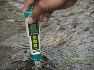
- Streams’ conductivity, pH, and concentrations of sulfate ions (SO42-), calcium (Ca2+), magnesium (Mg2+), habitat quality, and number of intolerant macroinvertebrate genera were compared between mined and unmined streams.
- Findings:
- Mining streams had higher conductivity and sulfate concentrations. With increased sulfate ions, calcium, and magnesium, it caused a 50 percent variation between mining streams and unmined streams. These findings also hint that large valley fills could be correlated with high concentrations of alkaline mining drainage.
- The number of intolerant macroinvertebrates declined in mined streams as the percentage of mining increased in the area.
- The findings relay that 22% of streams in the region drain catchments with mining extensive enough to be classified as biologically impaired based on state criteria and 32% of river catchments stream length have led to decreased intolerant taxa.
- 772 km of streams from this study were filled by coal mining overburden with 4 to 6 times more biological and biodiverse impairment through the regional river network.
- Dramatic losses of sensitive taxa occurs when conductivity or sulfate concentrations exceed the standard range due to 2.2 % of the catchment surfaces being mined.
- Conclusions:
- Sensitive taxa and the quality of the streams and rivers have a correlation with mining prevalence proximity and impact.
- Conductivity and sulfate concentrations significantly impacted stream and river biota.
- Implications:
- Rivers and streams are sensitive to mining pollution and should be taken into consideration when permits are given to mining industries.
- Policy Considerations:
- Although stream and river testing samples are used as a way to keep mining impact in check, is it actually helping the quality of these regional waterways? According to the findings in this article, they are not.
- Funded by and/or conducted by:
- The Foundation for the Carolinas and the Sierra Club.
- Jeff Bailey, Greg Pond, C. Hawkins, B. McCluskey, M. Palmer, S. Qian, J. Snyder, and K. Voss were imperative to the work done for this article.
Citation: Bernhardt, ES, et al. “How Many Mountains Can We Mine? Assessing the Regional Degradation of Central Appalachian Rivers by Surface Coal Mining.” Environmental Science & Technology, vol. 46, no. 15, n.d., pp. 8115-8122. EBSCOhost, proxyiub.uits.iu.edu/login?url=http://search.ebscohost.com.proxyiub.uits.iu.edu/login.aspx?direct=true&db=edswsc&AN=000307199800028&site=eds-live&scope=site.